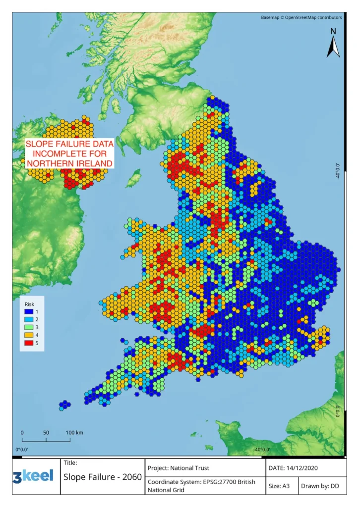
• Twitter
  • LinkedIn
  • Mail
+44 (0)1865 236 500
3Keel
  • About us
    • Team
    • Work with us
    • Our sustainability
    • Social responsibility
  • Practice areas
    • Climate Change
    • Circular Economy
    • Sustainable Commodities
    • Landscape Innovation
    • Resilient Agriculture
    • Bespoke Research
  • News & Insights
  • Projects
    • Clients
    • Published reports
    • Case studies
  • Contact
  • Search
  • Menu Menu
Sustainability advisors
CASE STUDY NATIONAL TRUST

‘A game changer’ – 3Keel and National Trust map climate risks to historic UK sites

We’ve been working with the National Trust and Geo Smart Decisions to create a ‘pioneering approach’ to mapping the key climate threats faced by historic sites in the UK at present and in the future.

Sustainable commodities
Resilient agriculture
Product ecodesign
Landscape innovation
Climate change
Bespoke analysis

AREA CLIMATE CHANGE

Image of report author, Joshua DeruLEAD JOSHUA DERU

CLIENT NATIONAL TRUST

T

he National Trust and 3Keel have been working together to assess climate risk, and recently collaborated with Geo Smart Decisions to develop a “game changing” map that illustrates the threat climate change poses to some of the Trust’s most iconic and culturally significant sites – and offers some solutions on how to tackle it.

It is the first map of its kind that plots data in this way and will help the charity identify the hazard level facing its countryside locations, monuments, coastlines and historical sites in England, Wales and Northern Ireland.

By plotting its places alongside existing data on climate change related events, the charity is able to understand how, at a local scale, potential risk factors (extreme heat and humidity, flooding, landslides, coastal erosion, soil heave and storms) could change by 2060.

Working to a worst-case model of no intervention on emissions, the map is intended to be used as a “flagging tool” to highlight potential hazards to the locality of a site. This will then be used to inform early intervention to mitigate damage by climate-driven risks.

The data also means landowners can come together with a joined-up approach and engage local communities to volunteer in their area and help with the fight. By identifying areas at risk, the charity can pinpoint locations that may need intervention like tree planting to slow water run-off, peat bog restoration to hold back water, river restoration or areas that need more shade due to extreme heat.

Assuming there was no intervention on emissions before 2060, key findings include:

  • Around 71 per cent of National Trust sites could face medium to high risks from climate related hazards by 2060 – an increase from 30 per cent today
  • Sites facing highest risks could triple, from 5 per cent to 17 per cent by 2060.
  • The number of National Trust scheduled monuments in the highest threat areas are projected to increase from 1453 today to 3861 by 2060.
  • Heat and humidity will rise dramatically, with the south east particularly susceptible to drastic increases. A third of National Trust sites in the region will experience at least 15 days of over 30 degrees a year. This will be exacerbated in urban areas like London, due to the Urban Heat Island effect.
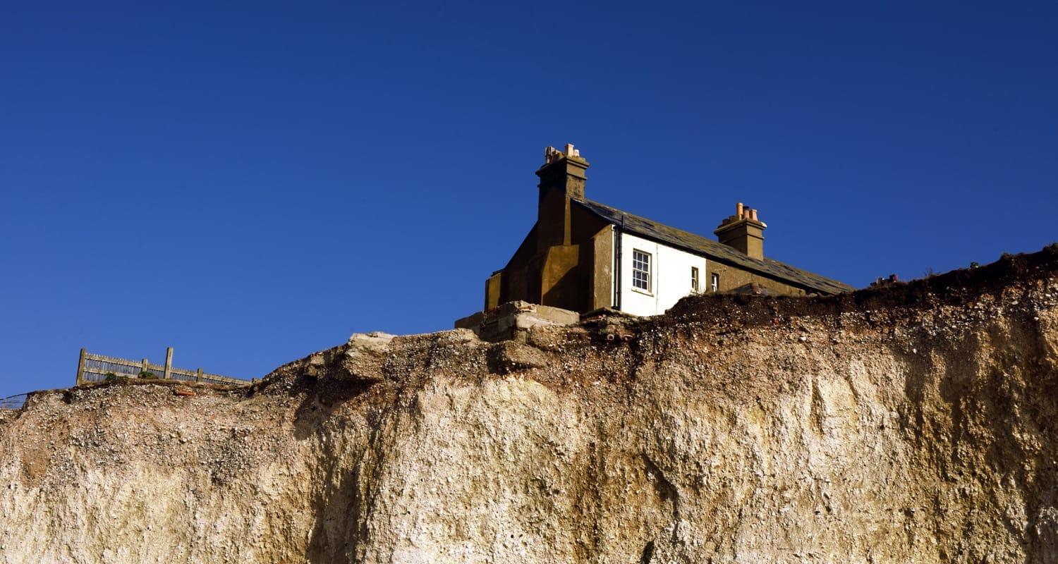
  • Storm damage, landslides and flooding we have experienced in recent years are set to become common occurrences and more widespread, particularly in Wales and the North of England
  • Coastal erosion and flooding will increase in Northern Ireland, potentially leading to more landslides around locations like the world-famous Giants Causeway.

The National Trust is already taking measures to try and tackle the threat posed by climate change by planting or establishing 20 million trees – an area the size of Birmingham – and becoming carbon net zero by 2030.

The next phase of the project will identify areas in which homes for wildlife are at risk and where species reintroduction like beavers may help the environment. Coastal areas at risk of collapse or sand dune movements due to rising sea levels will also be highlighted in the future, which will also enable physical intervention.

Water or heat adaptive building materials will be used in areas shown as high risk from flooding or rising temperatures and humidity, or even inform where to build if an area is prone to soil heave. The charity’s historic buildings and collections can be protected from extreme weather conditions and resultant increase in pests and damage arising from humidity and water.

The release of the map comes eight months before world leaders gather in Glasgow for COP26 to formulate a global plan on how to tackle the climate crisis at a global level. The Trust is already working in partnership with government bodies to plot all cultural heritage sites in the UK. The next phase of the map will further refine the methodology to really tackle the impact of the crisis at home.

Check out the mapping tool here.

Share this entry
  • Share on Twitter
  • Share on LinkedIn
  • Share by Mail

“This map is a game changer in how we face the threat climate change poses to the places we care for. While the data draws on a worst-case scenario, the map paints a stark picture of what we have to prepare for. But by acting now, and working with nature, we can adapt to many of these risks.

One of the most exciting opportunities here is the map ensures a joined-up approach in which neighbours, landowners, charities and developers can come together to identify risks and collectively intervene to tackle issues and make large scale change.

Planting trees, restoring peatlands, slowing the flow of water in flood prone river valleys and preparing our places and collections for the increased heat and humidity are some of the measures this map can inform.

And government can play its part by strengthening its environment bill and setting out a detailed and fully funded net zero delivery plan before world leaders come together at COP26 in November.”

Harry Bowell, National Trust Director for Land and Nature 

“This map will support our research and analysis into the vulnerability and exposure of some of the nation’s most important and sensitive heritage sites to future climate change.

The pioneering approach could be used to inform our thematic reports and has the potential to shape the future of how we need to adapt to avoid some of the worst impacts of climate change at a local granular level.”

Spokesperson, Climate Change Committee 

Sample map showing future risk from landslides in the UK (1 = low risk, 5 = high risk)

More case studies you may be interested in

Guidance on consumer-facing sustainability labels

December 10, 2019
CLIENT UN FAO
https://www.3keel.com/wp-content/uploads/2019/12/a-couple-shopping-for-food-sf.jpg 200 360 Richard Scott https://www.3keel.com/wp-content/uploads/2017/10/3keel_logo_340x156-01.png Richard Scott2019-12-10 16:18:312022-06-09 14:45:06Guidance on consumer-facing sustainability labels

Fact sheet on strawberry production published

August 20, 2018
A fact sheet written by 3Keel summarising the pros and cons of moving from...
https://www.3keel.com/wp-content/uploads/2018/08/strawbs-cover-1.png 200 360 Richard Sheane https://www.3keel.com/wp-content/uploads/2017/10/3keel_logo_340x156-01.png Richard Sheane2018-08-20 07:08:052020-02-21 11:57:22Fact sheet on strawberry production published

Farming systems review for climate analysis

February 28, 2018
CLIENT SYNGENTA
https://www.3keel.com/wp-content/uploads/2018/02/lowres-large-view-on-a-sunflower-field.jpg 200 359 Richard Sheane https://www.3keel.com/wp-content/uploads/2017/10/3keel_logo_340x156-01.png Richard Sheane2018-02-28 09:49:322021-01-29 15:57:47Farming systems review for climate analysis
Sign up for our newsletter

By clicking ‘subscribe’ you agree to receive marketing communications from 3Keel. You can unsubscribe from these updates at any time. For more information click here to see our privacy policy.

    Twitter
    Linkedin
    Mail
3keel green hosting certificate
Get in touch

+44 (0)1865 236500

office@3keel.com

B-Corp
Registered office

7 Fenlock Court
Blenheim Business Park
Long Hanborough
Oxfordshire
OX29 8LN
United Kingdom

3Keel LLP – Sustainability advisors Company registered in England and Wales Number OC394665© Copyright - 3keel
Scroll to top

This site uses cookies. By continuing to browse the site, you are agreeing to our use of cookies.

Accept settingsHide notification onlySettings

Cookie and Privacy Settings


How we use cookies

We may request cookies to be set on your device. We use cookies to let us know when you visit our websites, how you interact with us, to enrich your user experience, and to customize your relationship with our website.

Click on the different category headings to find out more. You can also change some of your preferences. Note that blocking some types of cookies may impact your experience on our websites and the services we are able to offer.

Essential Website Cookies

These cookies are strictly necessary to provide you with services available through our website and to use some of its features.

Because these cookies are strictly necessary to deliver the website, refusing them will have impact how our site functions. You always can block or delete cookies by changing your browser settings and force blocking all cookies on this website. But this will always prompt you to accept/refuse cookies when revisiting our site.

We fully respect if you want to refuse cookies but to avoid asking you again and again kindly allow us to store a cookie for that. You are free to opt out any time or opt in for other cookies to get a better experience. If you refuse cookies we will remove all set cookies in our domain.

We provide you with a list of stored cookies on your computer in our domain so you can check what we stored. Due to security reasons we are not able to show or modify cookies from other domains. You can check these in your browser security settings.

Google Analytics Cookies

These cookies collect information that is used either in aggregate form to help us understand how our website is being used or how effective our marketing campaigns are, or to help us customize our website and application for you in order to enhance your experience.

If you do not want that we track your visit to our site you can disable tracking in your browser here:

Other external services

We also use different external services like Google Webfonts, Google Maps, and external Video providers. Since these providers may collect personal data like your IP address we allow you to block them here. Please be aware that this might heavily reduce the functionality and appearance of our site. Changes will take effect once you reload the page.

Google Webfont Settings:

Google Map Settings:

Google reCaptcha Settings:

Vimeo and Youtube video embeds:

Other cookies

The following cookies are also needed - You can choose if you want to allow them:

Accept settingsHide notification only